PREVIOUS
Hytera to Showcase AI Powered Critical Communication Solutions at CCW 2026


Wildfires have evolved into a year-round global threat, often overwhelming traditional suppression methods. In response, Airbus has transitioned from providing individual aerial assets to delivering a comprehensive, integrated ecosystem: the Wildfire Sentinel. This innovative approach bridges the critical gap between ground teams and aerial assets, replacing reactive tactics with a proactive, data-driven "digital shield" that ensures seamless data exchange and enhanced tactical awareness for safer, more efficient operations.
In traditional firefighting, pilots often have to "find" the fire through dense smoke and coordinate with the ground operations via voice radio. The Wildfire Sentinel transforms this experience by providing pilots with Precision Drop Assistance information while providing rigorous deconfliction protocols and hazard enforcement for all ground and air personnel.
The system further closes the information gap by integrating satellite imagery, such as Pléiades Neo, to assess topography, vegetation and fuel loads. When combined with real-time infrared drone data, this integration eliminates the critical "information lag" that could allow small fires to escalate into uncontained mega-fires. This speed is vital: for high-risk fires, the probability of initial attack success exceeds 90% if the first suppressant drop occurs within 30 minutes of detection, but falls below 30% after two hours.
The operational phases of the ecosystem
The Wildfire Sentinel operates through a seamless, end-to-end mission cycle with eight operational phases, designed to protect lives and landscapes.
1. PREPARE: Risk Mapping & Mitigation Before the first spark, this phase builds a foundation of readiness. By leveraging Airbus OneAtlas, Wildfire Sentinel transforms high-resolution satellite imagery into detailed risk maps. This allows agencies to analyse topography and vegetation density, creating data-driven mitigation plans to harden landscapes against potential threats.
2. CONNECT: Resilient Communication Backbone Information is only as good as the network that carries it. CONNECT utilises Agnet by Airbus to establish a rapidly deployable tactical network. By integrating Long Term Evolution (LTE), SatCom, and Mesh technologies, the Wildfire Sentinel ensures a seamless and redundant data flow between field teams, aircraft, and command centers.
3. OBSERVE: Comprehensive Situational Awareness Airbus provides eyes beyond the horizon using the Airbus family of unmanned systems, including Aliaca, Flexrotor, SiRTAP, Zephyr and other high speed FPV (First-Person-View) drones. By fusing live EO/IR imagery with meteorological data, the Wildfire Sentinel generates a real-time Common Operational Picture (COP) that keeps decision-makers ahead of the fire’s path.
4. LOCALISE: Precision Geolocation & Tracking Safety depends on knowing exactly where every asset is positioned. This critical step focuses on the universal tracking and 3D georeferencing of all ground and air assets. By mapping fire features and personnel in a shared spatial environment, we eliminate ambiguity in the heat of the mission.
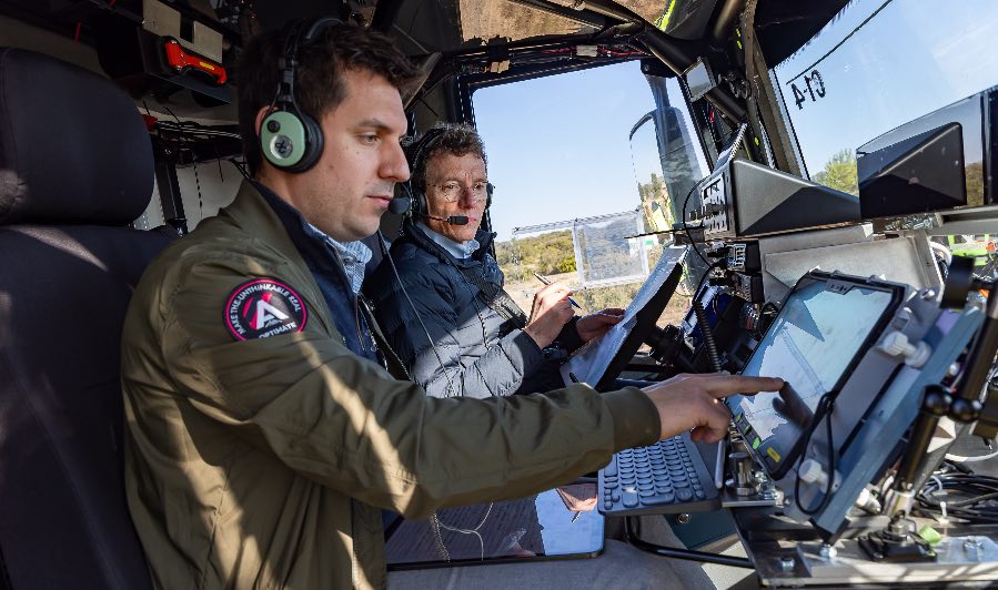
5. COLLABORATE: Intelligent Strategy & Assessment Precision is the key to efficiency. Using the Airbus Optimate system, the Wildfire Sentinel leverages AI-driven modeling to calculate optimal water drop trajectories. This intelligence allows for immediate post-drop assessments, ensuring every liter of suppressant is utilised for maximum impact.
6. COMMAND: Coordinated & Secure Directives Effective response requires a single source of truth. COMMAND centralises mission-critical orders, enforcing strict safety protocols. Through automated deconfliction and real-time hazard zone alerts, we ensure that complex multi-agency operations remain organised and secure.
7. SUPPRESS: High-Capacity Aerial Firefighting When it’s time to engage, the Wildfire Sentinel deploys a versatile fleet of Airbus helicopters (H125, H145, H215, H225) and heavy-lift aircraft like the A400M and C295, alongside the HYNAERO’s future Fregate F100 amphibious water bomber. These platforms support both direct and indirect attacks, delivering water and retardant with unmatched reliability. Under a standard two-hour mission profile, the H225 showcases this efficiency by executing 24 rotations at rapid 5-minute intervals to drop a massive 96,000 litres of suppressant.
8. REPLAY: Post-Mission Analysis & Learning The mission doesn't end when the fire is out. Through REPLAY, the system creates a full digital reconstruction of the entire operation. This "black box" approach allows for systematic after-action reviews and high-fidelity training simulations, ensuring continuous operational improvement for future missions.
A "Lego-like" Modular Framework
The Wildfire Sentinel is designed as a highly adaptable, scalable solution. Because it is built to reinforce legacy firefighting systems, it allows new technology to bridge the gap between existing ground and air operations while being tailored to a region's specific geography and assets.
The system combines Airbus’s modular building blocks (aircraft, communications, and flight operations) with partner solutions to create a resilient, unified ecosystem. This ensures seamless data exchange and closer coordination between ground and air teams, providing the real-time tactical awareness needed for safer decision-making.
Proven in the Field The foundation of the Wildfire Sentinel was solidified during a landmark March 2026 trial in Nîmes, France. Conducted with the French fire and rescue services (SDIS) and Entente Valabre (the international authority in wildfire training), Airbus proved that real-time data fusion reduces the window between fire detection and extinguishment.
By synchronising the entire intervention chain - from satellites to boots on the ground - the Wildfire Sentinel ensures that technology serves as a force multiplier for those who risk their lives to protect us and our environment.